
Ari Johnson
The expression goes that a picture is worth a thousand words. Whatever the case may be, words and maps aren’t that dissimilar. A word is a way of representing an inner thought in a way that is intelligible to another person. Some words have hidden meanings, such as ‘civilization’ or ‘wilderness.’ Likewise, a map is full of the potential for boas, with the cartographer (on purpose or not) omitting some data, and exaggerating other data.
In other words, maps tell a story both by visual representation, as well as by saying something about the cartographer.
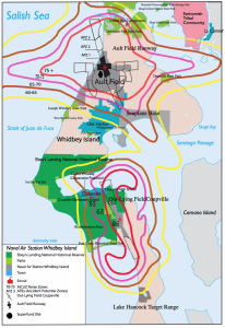
My map above representing areas used by Growler naval aircraft on Whidbey Island depicts the Ault Field and Out-Lying Field (OLF) Coupeville runways, but not the flight patterns of the planes. But one can “read” the flight paths from the decibel patterns, and from the “Accident Potential Zones” (APZs) tied in with the use of the runways. An Accident Potential Zone represents the area most likely to be affected should an aircraft-related accident occur.
I will be providing a detailed account of the inspiration which led me to create this map, as well as explaining my process in creating the map.
At the tip of northern Whidbey Island is a small campground staffed by lovely folks from the Washington State Park service. Cornet Bay Retreat Center, as it fittingly called is “[a] popular place for both small and large groups alike[.] [G]uests enjoy the beautiful surroundings of old growth trees, abundant wildlife and a variety of activities including kayaking, fishing, and miles of hiking trails” (Washington State Parks).
I had come, like so many others, to this region of the Puget Sound to enjoy nature, be at peace, and, well, retreat.
But what is this flying above my head in the silent night? It was an EA-18G Growler jet (listen to video), capable of reaching eardrum-rupturing decibel ranges, and it was flying low enough to make its wings clearly visible as they chopped through the wind. Its sound reverberated within audible range for about 20-30 seconds after its tail had exited visibility (See Noise Issues).
This experience was a jolt and a juxtaposition. It was jolting because it is a physical reverberation throughout the inner workings of one’s gut, one’s ears, and one’s brain. It was a juxtaposition because the reality of militarization had occupied the same space (in the physical and in the mental realms) as serenity and decompression.
This is the reason why parklands, whether historical, state, public, national, or tribal are visually apparent on my map. It is is because my experience with the noise on Whidbey Island has to do with its infringement upon my serenity, a view echoed in the film Battle Ready by various military veterans who had been hoping to find tranquility in Olympic National Park, not too far from Whidbey Island, and polluted by noise from the same Growlers as are flying by Deception Pass. These veterans were made to recall memories of combat by the intensity of the noise pollution above Olympic National Forest, showing how the wars abroad make their way back home.