Permission to use with attribution: Zoltán Grossman, Unlikely Alliances, https://sites.evergreen.edu/unlikelyalliances
Water protectors blockading and locking down bulldozers that had cut a swath through North Dakota ranchlands and tribal sacred sites for the Dakota Access Pipeline, north of the Standing Rock Sioux Reservation, on September 6, 2016.
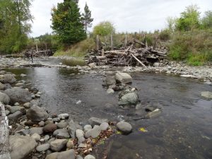
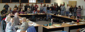
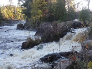
Water protectors blockading and locking down bulldozers that had cut a swath through North Dakota ranchlands and tribal sacred sites for the Dakota Access Pipeline, north of the Standing Rock Sioux Reservation, on September 6, 2016.Pacific Northwest canoes arrive at North Dakota’s Cannonball River, in a display of solidarity with the Standing Rock Sioux Tribe’s fight against the Dakota Access Pipeline, on September 8, 2016.The Quinault Indian Nation hosts the “Shared Waters, Shared Values” rally against a proposed Grays Harbor oil terminal, at Hoquiam City Hall on July 8, 2016. Quinault president Fawn Sharp and vice president Tyson Johnston are joined by representatives of the Quileute, Makah, and Lummi tribes, Washington fishing association representatives, and local environmentalists.Northwest treaty rights leaders Billy Frank Jr., Hank Adams, and Jewell James at Lummi totem pole journey stop at Washington State Capitol in Olympia, on September 24, 2013.Logjams on the Mashel River, part of the Nisqually Tribe’s salmon habitat restoration program in the Nisqually River watershed of western Washington.The Black Hills Wild Horse Sanctuary, on the site of the formerly proposed Honeywell munitions testing range near Hot Springs, South Dakota.Crandon mine opponents celebrate at the headquarters of the Nicolet Minerals Company, after its 2003 purchase by the Mole Lake Sokaogon Chippewa and Forest County Potawatomi tribes in northern Wisconsin.Crandon mine opponents celebrate at the headquarters of the Nicolet Minerals Company, after its 2003 purchase by the Mole Lake Sokaogon Chippewa and Forest County Potawatomi tribes in northern Wisconsin.Mole Lake Ojibwe Vice-Chair Tina Van Zile and Ladysmith farmer Roscoe Churchill cut a cake to celebrate the 2003 victory over the Crandon mine project, at the Mole Lake Sokaogon Chippewa tribal headquarters in northern Wisconsin, as sportfisher Bob Schmitz cheers.Native and non-Native members of the Wolf Watershed Educational Project celebrate their 2003 victory over the Crandon mine project, at the Mole Lake Sokaogon Chippewa tribal headquarters in northern Wisconsin.Big Smokey Falls on the Wolf River in the Menominee Reservation, downstream from the proposed Crandon mine in northern Wisconsin.